The largest earthquake since 1954 is a reminder that Nevada moves in many directions

Each decade, Nevada grows by about two basketball courts.
It's hard to quantify, state geologist Jim Faulds says, but the comparison is about right. That's because most of Nevada sits in the Basin and Range province, which is stretching. Things are moving in other ways too. Central Nevada is moving to the right relative to the Sierra Nevada by about a centimeter each year. The movement is constant, but it's usually absorbed by faults.
Walking outside on a warm summer afternoon or hiking in the backcountry, it's easy to forget the dynamism underneath the Earth's surface — until these movements cause a major earthquake.
That's what happened in the early morning of May 15. About 75 miles outside of Tonopah, a big quake occurred on a fault trending roughly east-west, Faulds said. The earthquake happened along what is known as the Walker Lane fault system, which runs through eastern California and Nevada. And it registered a magnitude 6.5, making it Nevada's largest earthquake in 66 years.
The quake's potential damage was blunted by the fact that its epicenter was outside of a town.
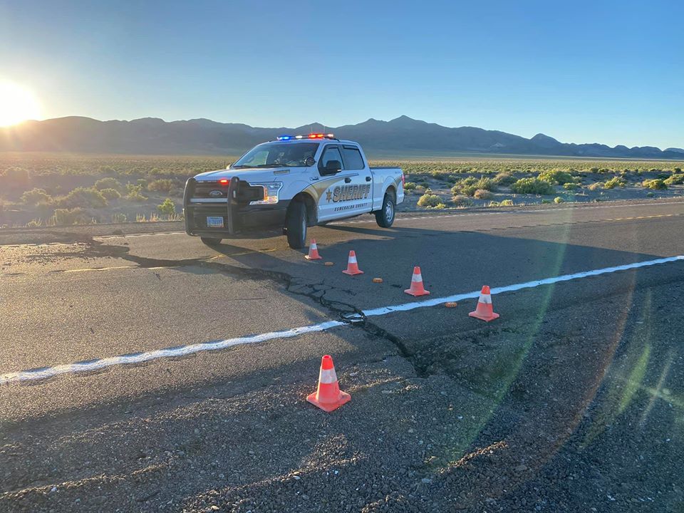
But it was still powerful enough that it caused damage on three highways, prompting Gov. Steve Sisolak to declare a state of emergency on Thursday. The state estimated that the earthquake caused at least $700,000 in damage to U.S. 95, U.S. Route 6 and U.S. Route 360 across three rural counties. The emergency declaration allows the state to unlock federal response funds.
The Nevada Independent talked to Faulds about the geology behind the tremor, how his team at the Nevada Bureau of Mines and Geology is responding and what it could mean for the future.
Geologically speaking, what happened?
The short answer is that the earthquake struck in a fault system known as the Walker Lane.
The Walker Lane area accommodates about 20 percent of the motion between the Pacific plate and the North American plate, Faulds says.

The more infamous San Andreas fault system accounts for about 80 percent of plate motion.
"So we expect earthquakes in this region," said Faulds, who directs the Nevada Bureau of Mines and Geology. "We know they've happened for millions of years."
"It's a good wake up call," he adds. "We do live in a seismically active region."
In fact, after California and Alaska, Nevada is one of the most seismically active states in the country, in part because of all of this movement across faults at varied angles and positions.
Wait, but what actually caused the earthquake?
The answer to that is the answer to why we don't feel earthquakes all the time.
The movement in Western Nevada, about one centimeter per year, is constant, and yet we don't feel quakes constantly, Faulds notes. That's because faults accommodate the movement.
But the movement builds up over time, and eventually "they finally let loose."
To explain what happens, Faulds uses an example of a book on a table.
Pretend you are pushing a book across the desk. A little force, and the book doesn't move. A little more force and it still doesn't move. A little more force, and suddenly the book moves.
"This build up of that motion — one centimeter per year, another centimeter the next year and so on," Faulds says. "And then all of the sudden, then one of these faults let's go."
And the aftershocks?
Since the recent M6.5 earthquake (the official name is the Monte Cristo Range Earthquake), there have been reports of hundreds of aftershocks reported in the area around Tonopah and Mina, a small town north on U.S. 95.
The Reno Gazette Journal reported a quake with a magnitude 5.0 Wednesday morning that was felt as far as Carson City and Sonora, a town on the western side of the Sierra Mountains.

Faulds said that the main earthquake triggers a lot of activity on the same faults or nearby faults. Or in some cases the fault ruptures, but a patch of the fault gets stuck. As a result, that area then ruptures or breaks too, Faulds says.
Back to the book example, but now with multiple books on the desk.
"That book is going to move a little bit, and then the other end of the book might hit another book on your desk, and so on," Faulds said. "And you'll sort of have this chain reaction.
Once the books reach the end of the desk, they aren't moving as much as the initial force.
"But they are still responding to that initial motion," Faulds said.
What does the response to this type of earthquake look like?
A lot of on-the-ground observations. Yes, even during the pandemic.
A team from the bureau, the U.S. Geological Survey, the Nevada Seismological Laboratory and the California Geological Survey were mobilized to document damage to highways and surface ruptures caused by the quake. The team appoints a chief coordinator for the response.
The team has observed, by surveying the surface rupture, a maximum offset of about six to eight inches. That's smaller than the several feet of offset caused by the magnitude 7.1 Ridgecrest earthquake in California last year, but Faulds said the offset was still "very measurable."

"Although they are finding new things every hour," Faulds noted in an interview on Thursday.
In this case, the earthquake mainly struck in a remote area. It's difficult to determine what the damage would have been had a similarly-sized quake ruptured underneath a town, but Faulds said "it probably would have caused some significant damages and probably some injuries."
"It all depends on the nuances of that particular earthquake," he said.
Acceleration rates, time of day, the number of old buildings in a locality.
But earthquakes, with even a smaller magnitude, can cause damage. Faulds pointed to the Christchurch, New Zealand earthquake in 2011, a magnitude 6.3 quake that killed 185 people and injured thousands more. It struck during lunch-hour with a high acceleration. In Nevada, the 2008 magnitude 6.0 earthquake in Wells, Nevada caused significant damage to the town.
"A 6.5 directly underneath a city is not a good thing," Faulds said.
And Yucca?
Every time there is a significant earthquake in and around Nevada — or in the Walker Lane fault system — the proposed Yucca Mountain nuclear waste site invariably enters the conversation.
"Last week's 6.5 magnitude earthquake less than 150 miles from Yucca Mountain only solidifies what my colleagues and I in the Nevada delegation have argued in our opposition against designating Yucca as the nation's sole nuclear waste repository site," Sen. Jacky Rosen wrote in a statement to E&E News, a publication that focuses on environmental policy coverage.
So from a geological perspective, what does this earthquake mean for the Yucca fight?
Faulds notes that Yucca Mountain is in the broader Walker Lane zone. But a lot depends on the specific faults that you have in the area around Yucca Mountain.
"How active are they and what magnitude earthquake are they likely to produce," he said. "The faults around Yucca Mountain will rupture in earthquakes, inevitably. And there's a number of young faults around Yucca Mountain just like in this area where the earthquake just occurred."
"There's lots of faults in that area that need to be reckoned with and understood," he added.
Support Independent Elections Coverage and Journalism in Nevada
You’ve enjoyed unlimited access to our reporting because we’re committed to providing independent, accessible journalism for all Nevadans.
But sustaining this work — informing communities, holding leaders accountable, and strengthening civic life — depends on readers like you.
Nevada needs strong, independent journalism. Will you join us?
A gift of any amount helps keep our reporting free and accessible to everyone across our state and funds our elections coverage.
Choose an amount or learn more about membership