
No matter where you go in Nye, Storey, Pershing counties, there you are

Happy Thanksgiving weekend, dear reader. With Christmas and its attendant gift-giving obligations soon upon us, you might be looking for some fun and comparatively free (not including recharging or refueling costs) places to visit in our state.
That's a shame. Best I can do is free.
For the past four weeks, I've been writing about unique destinations in each of Nevada's counties that speak to our state's character and history. Last week's entry in this series featured Walker Lake in Mineral County, which only requires gas or electricity money to visit. This week, I present three additional destinations of similar frugality for you to add to your growing bucket list.
If you're afraid of water, good news — these destinations mostly don't have any.
None of these destinations, however, are fun in the traditional sense, or so I've been told by more than a few passengers. Your mileage, however, may vary.
Nye County: Railroad Valley
For once, I am not going to poke fun at Nevada's largest county.
Yes, Nye County's politics are and shall likely always raise an eyebrow or two. Sometimes the county's voters elect a dead brothel owner to the Assembly. Sometimes they elect county commissioners who appoint Michele Fiore as a judge. Sometimes they want their county clerk to count tens of thousands of ballots by hand.
This week, that's all beside the point. Nye County isn't just its people. It's also a place.
As a place, Nye County, for all of its idiosyncrasies, is full of beauty and history. Tonopah has, in my opinion, the perfect blend of modern tourist-friendly conveniences and early 20th century mining history if you're the sort who's allergic to kitsch but enjoys reliable air conditioning. If you prefer your ghost town explorations to be a bit rougher but still want to stick to pavement, Belmont is another hour away. Rhyolite, a briefly extant mining town west of Beatty, hosts an astonishingly unique art installation only miles from the highway linking Nevada's two largest metropolitan areas.
Then there's the hiking.
Mount Jefferson and Arc Dome, two of the most prominent peaks in the Great Basin, have been on my bucket list for a while now. The Toiyabe Crest National Recreation trail (its northernmost branch extends into Kingston Canyon in neighboring Lander County) delivers 62 miles of beautiful solitude.
The pictures almost have me convinced that backpacking for several days in a stretch could be a good idea.
If ghost towns and hiking aren't your thing, book a tour of the Nevada National Security Site, where you can get the former test site's perspective on its place in the history of nuclear weapons testing. Or drive to Lunar Crater, which only looks like it was created by a nuclear bomb (it's actually the product of natural volcanism).
There is no shortage of pleasant and breathtaking places to go in Nye County.
The place I'm going to recommend you visit, however, isn't one of them.
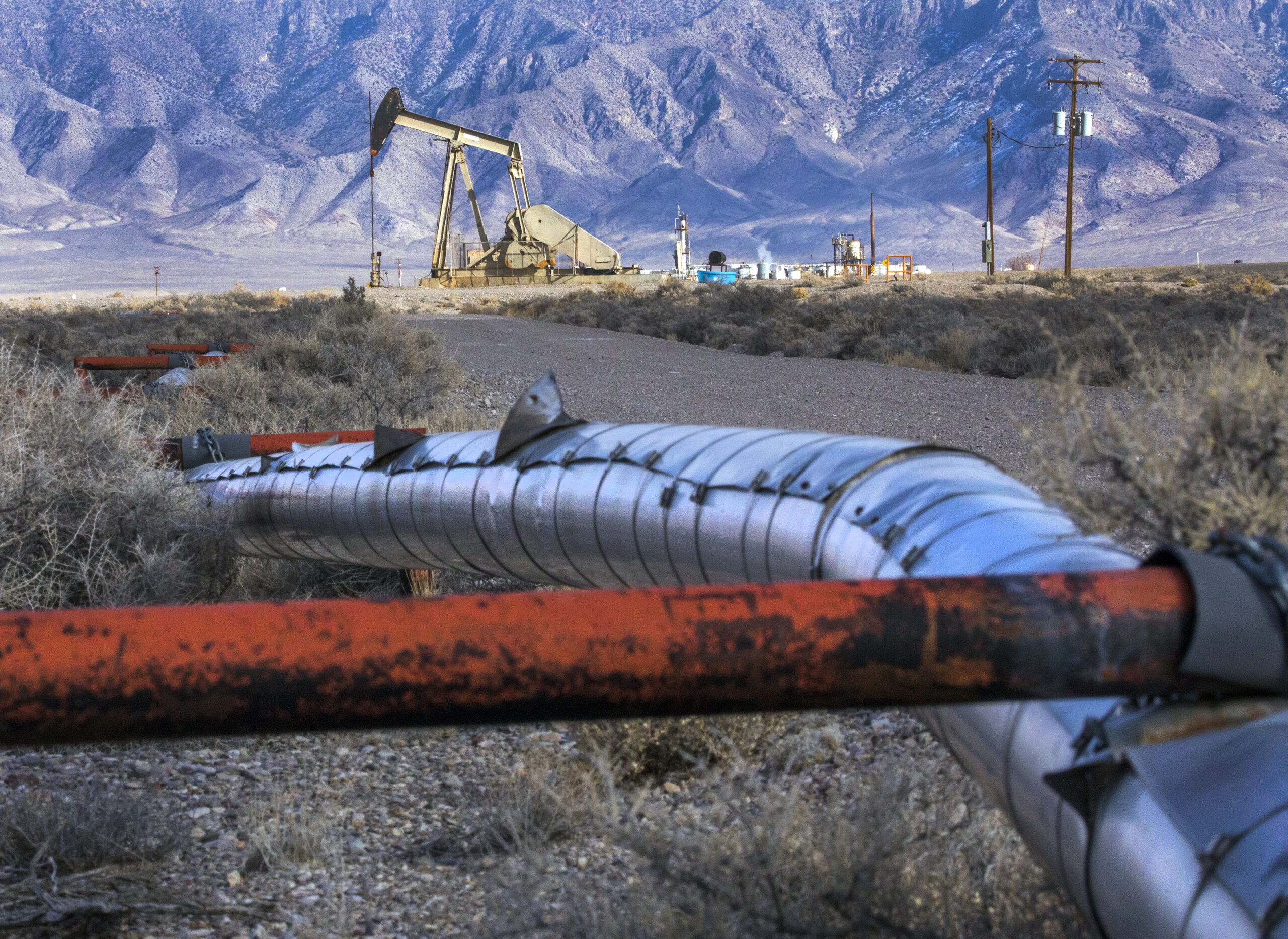
Visually, Railroad Valley is largely unremarkable. It presents itself as one of a series of unremarkable low points between a series of unremarkable transverse mountain passes travelers must pass through as they journey across Nevada. Driving through the valley on U.S. Route 6, you'll see a few ranches, the occasional spring-fed tree grove, and mile after mile of sagebrush.
You'll also pass the only oil refinery in the state, as well as Nevada's most consistently productive oil field.
If you pay especially careful attention to the dirt the sagebrush is growing out of, you'll notice that it gets a bit paler as you get closer to the middle of the valley. That pale dirt, a product of a long-evaporated lake, might contain one of the world's largest lithium deposits.
Railroad Valley might be the only place in Nevada that contains economically recoverable amounts of both our past and future energy storage sources.
That's not the only thing that makes Railroad Valley unique. Railroad Valley is the only home for the Railroad Valley toad, an endemic species whose habitat is limited to a single small spring in the valley. It's also been used by NASA to calibrate satellites for decades.
Because of the toads and the satellites, however, NASA and environmentalists are not enthusiastic about additional development within the valley. NASA, for example, is preventing development on 36 square miles of the valley floor, while the Center for Biological Diversity is suing to halt further development.
That's why, from the smallest tadpole to the farthest satellite, from energy's past to its future, all eyes are on Railroad Valley.
The next time you drive through a seemingly unremarkable desert valley in Nevada, think about Railroad Valley and ask yourself if there isn't more to it than meets the eye in your surroundings. If you want to visit the real deal, meanwhile, simply pick an end of U.S. Route 6 and point your vehicle toward the other side of Nevada. If you pass a sign that says, "Next gas 163 miles," you're probably traveling in the right direction.
Just make sure you have a full tank of gas or a full charge.
Pershing County: Lovelock Cave
When settlers first approached Lovelock Cave, the only thing they cared about was the guano — the bat poo — lining the floor and walls of the place.
The reason the settlers cared so much about the guano is because it makes an excellent fertilizer, especially when you're farming before the dawn of the age of nitrogen-based artificial fertilizer. Guano is so effective at fertilizing crops that the 1856 Guano Islands Act, which permitted the United States to claim any island with guano on it so long as there were no other claims or inhabitants, arguably birthed our nation's somewhat troubled history with overseas dependencies.
If you ever want to listen to an hourlong podcast episode about the Guano Islands Act and the birth of American imperialism, by the way, you probably can't do much better than episode 15 of Ed Burmila's Mass for Shut-Ins. Don't worry, you'll have time to listen to it on your drive to the cave.
But I digress.
Point being, before the birth of artificial fertilizer and the rest of the foundational technologies that would eventually develop into the Green Revolution, it wasn't easy to give crops the nutrients they needed to thrive and grow, especially in Nevada's arid and nutrient-poor soil. Finding and exploiting sources of nitrogen-containing organic biomass, such as guano, was critical to the success of Nevada's farming economy.
More critical, in fact, than the preservation of the historical artifacts left behind by the cave's previous visitors — at least at first.
Lovelock Cave, it turned out, wasn't just used by bats as a daytime rest stop from the desert. The cave was also used as a supply cache by Native Americans for over 4,000 years. During its ongoing use by the Northern Paiute, the cave was used to store various hunting tools and doubled as a mausoleum.
Unfortunately for the recorded history of our state's native tribes, the cave also contained nutrient-rich guano and guano was big business. Within a year, miners harvested 250 tons of guano from the cave — guano that also contained the remains of various people as well as their artifacts.
In effect, the miners harvested the remains of the dead to fertilize the crops of the living.
After the guano was mined in 1911, the University of California sent a lone archeologist to look through what was left. Within a span of four months in 1912, L. L. Loud found roughly 10,000 artifacts and human remains still in the cave. That expedition quickly instigated further research from museums throughout the country. Gov. James G. Scrugham received a mummy from one such expedition in 1924. The Smithsonian Institute announced there would be additional research in 1926.
Even during the Roaring '20s, the cave's contents were considered foundational in understanding the history of Native Americans throughout the Southwest. Saying that, however, elides a number of assumptions. Considered foundational by whom? Whose understanding was improved by the discovery of the cave? The Northern Paiute surely understood the importance of their 4,000-year-old supply cache.
Also, why did Nevada's governor need the body of a long-dead mummified child?
Over the subsequent century since Lovelock Cave was first stripped for fertilizer and then stripped for artifacts by generations of archeologists, attitudes regarding how Native American remains should be treated have shifted markedly. As The Nevada Independent reported a few months ago, many of the museums that received artifacts from sites such as the Lovelock Cave are now working to return the artifacts and human remains they collected back to the descendants of those who originally lived, worked and died in those sites.
They have not, however, returned all of them. Some of them may never be returned.
One such collection of artifacts includes our official state artifact, the tule duck decoy. A collection of eight decoys, each at least 2,000 years old, along with three additional decoys under construction, were found in Lovelock Cave.
If you want to visit those decoys, you have to leave the state since they're in the Smithsonian's National Museum of the American Indian in Washington, D.C. If you'd like to visit the site where they were found, however, all you need to do is drive 40 minutes on the Lovelock Cave Backcountry Byway. There you'll find well-marked trails and informational signs describing the cave and its history.
Storey County: Six Mile Canyon Road
Storey County is home to Virginia City, Nevada's first boomtown.
Visit it if you want. Everyone else does.
Perhaps it's because I live a half-hour drive or so from Virginia City. Perhaps I'm not particularly fond of crowds. Perhaps I have other things to do than eat tourist-grade saltwater taffy, stare at the exhibits of several rock stores, and get the occasional drink at some bar that looks like a Hollywood set piece from some insufferably dull show my parents used to watch when they were children.
Perhaps.
Whatever the reason, I don't like Virginia City. Bah, and might I further add, humbug.
My dislike of Virginia City, to be clear, should not be interpreted as a moral statement. If you like Virginia City, that's fine. Plenty of people do and I don't hold that against you. Sometimes, when the stars align and the mood is right, I can have a good time in Virginia City, too.
In my opinion, liking or disliking Virginia City does not make you a better or worse person. Chances are, there are places I like and interests I enjoy that you would likely find completely tiresome. As the youths like to say, it's sometimes OK to let people enjoy things.
Enjoy Virginia City! If, following a particularly unfortunate series of events you find yourself there, you'll be in a better mood if you do. There's a train and everything. It's fun! Have a good time.
If you can't bring yourself to, however, consider enjoying my favorite way of leaving the place.
If you're coming from Reno, getting into Virginia City involves taking State Route 341 through Geiger Grade. That means the drive often involves getting stuck behind someone who is either incapable or unwilling to take turns at speed. There is, unfortunately, no way of getting around that — the original Toll Road is for athletes and offroad vehicles now.
If you're coming from somewhere south of Virginia City, or if you don't mind taking the long way back to Reno, you have more options. You could, for example, take the southern leg of State Route 341 through the less steep but considerably longer Occidental Grade route — this doubles as the truck route. You could also take the road through Silver City and Gold Hill on State Route 342, which features remarkably tight corners and steep grades.
The Silver City and Gold Hill route is an entertaining way to leave. It's also an entertaining way to get there if you're ever coming from that direction, especially if you're one of the few Americans still driving with a manual transmission.
The best way to leave, however, is State Route 79, which passes through Six Mile Canyon.
The reason it's the best way to leave is because most people don't know it's there. If you don't know the arrow pointing to the local senior center happens to also be the turnoff you need to get on an otherwise unmarked state highway, you'll just think you're passing another leg of Virginia City's historical street grid. If you make the turn, the street doesn't reveal its destination — there's no state highway chevron or mileage sign letting you know you're about to drive to Dayton.
You just start driving and, after passing a few stop signs, keep going.
As the name might suggest, Six Mile Canyon is not a long drive. Over the course of its accurately eponymous mileage, however, you will pass abandoned headframes, drive over narrow bridges and steer through a narrow wooded canyon.
Best of all, unlike the rest of Virginia City's exits, you'll be noticeably somewhere else after six miles.
If you have to head back to Reno, yes, this is the long way home. On the other hand, the long way home features multiple passing lanes and, once you get to Washoe Lake, a 70 mile per hour speed limit. After getting stuck behind someone struggling to get their recreational vehicle over Geiger Grade, you'll likely be thankful for the elbow room.
David Colborne ran for public office twice. He is now an IT manager, the father of two sons, and a weekly opinion columnist for The Nevada Independent. You can follow him on Mastodon @[email protected], on Bluesky @davidcolborne.bsky.social or email him at [email protected].
Support Local Journalism
You’ve enjoyed unlimited access to our reporting because we’re committed to providing independent, accessible journalism for all Nevadans.
But sustaining this work — informing communities, holding leaders accountable, and strengthening civic life — depends on readers like you.
Nevada needs strong, independent journalism. Will you join us?
A gift of any amount helps keep our reporting free and accessible to everyone across our state.
Choose an amount or learn more about membership